


HOW LONG IS THE SUN IN "YOUR" SKY TODAY?Accuracy generally within  0.05 hr ( 3 min)Shadow adjusted for Effects of Twilight
Calculations assume a flat horizon
At map's right, drag blue Slider to select Latitude:
Fine tune Lat with Arrow keys (most browsers)
Sun Partly / Fully Above Horizon:
Sun Fully Below Horizon:
°
hr
hr
View "preceding"
Earth in its orbit
View "trailing"
Earth in its orbit
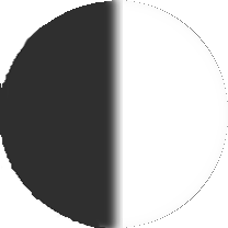
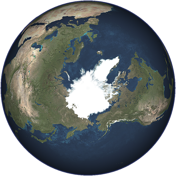
 These 5 world views reveal the current extent of day and night on Earth! To the above map's right, drag the blue Slider to your Latitude to find how long today's Sun is in your sky. If, as in Safari, your browser does not support fine-tuning Slider values with Arrow Keys, try this. Most accurate for tropical and mid latitudes, this tool is only a bit less so toward the poles, where Earth's terminator—its line between day and night—"flattens out". Still, you will get a good sense of how long the Sun is above your horizon today—and how this varies throughout the year.
Knowing how long the Sun is in your sky today can be useful. Travelers often wish to know how many hours of daylight to expect on anticipated trips. In addition, ********* the
insights may be revealed about phenomena not generally considered to be astronomy-related. For example, it intrigues many people that Alaska grows impressive crops during its short growing season of late-spring through early-summer. While this may seem paradoxical at first, near the June Solstice the display above will reveal that Anchorage, Alaska receives over 19 hours of sunlight per day! As photosynthesis fuels plant growth, Alaska's crop yields become much less surprising. Hence, two seemingly unrelated sciences are seen to be connected!
The map and calculated times above will dispel the myth that equatorial days and nights are of exactly equal lengths! On average, each day at the Equator the Sun is partly or fully "above" the horizon for about 12 hours 7 minutes, and fully "below" the horizon for about 11 hours 53 minutes! In part this is because the Sun is not a point-source of light but a disk of about one-half of a degree in diameter in our sky. (Our Current Apparent Sizes of the Sun & Moon page has more on this.) So the Sun's "leading edge" peeks above the horizon slightly before its center at sunrise, and its "trailing edge" persists above the horizon slightly after its center at sunset. Also, atmospheric refraction at the hori- zon visually displaces the Sun "upwards" by roughly one-half of a degree (on average), so we see it rise a bit earlier and set a bit later than it would if Earth had no atmosphere. For these same reasons, at the equinoxes the durations of day and night elsewhere are unequal as well, though overall they are "more equal" than at any other times of year.
Actually, finding "exactly" how long the Sun will be fully or partly above your horizon on any day is so complex that claims of ultra-high accuracies—within seconds or less, for instance—are untenable. Along with your latitude, other factors—your altitude, local topography, Earth's oblateness and slight pear shape, the Sun's changing apparent size during the year, where and how fast Earth is currently moving in its orbit, your local atmosphere's current refractive index, even Earth's tides—can very slightly affect when the Sun peeks over your particular horizon and later fully de- scends below it, i.e. your local sunrise and sunset. But latitude is the overriding factor by far, likewise determining how long the half-degree-diameter solar disk requires to completely appear and disappear at your horizon.
 At the Equator the Sun generally rises fully or sets fully in about 2 minutes. However, as The Sun's Skypath reveals, durations of sunrise and sunset increase with distance from the Equator. This is because the geometry of our spherical Earth, and our planet's varying tilt relative to the Sun during the year, cause the solar orb to rise and set "more shallowly" at less equa- torial latitudes. At the poles the effect is so extreme that the 6-month polar days start and end with sunrises and sunsets so shallow that they last over 32 hours! At less-polar Arctic latitudes the same effect similarly "blurs" the transition from day to night. Wherever Earth's terminator "looks flat" on the map above, the Sun can appear to "linger" just above, at or just below the horizon! So at certain times of year locations in Alaska, Canada, Scandina- via and Russia experience short nights that do not darken beyond twilight!
The pattern of illumination over Earth—shown in the map near the top of this page—is determined, of course, by our planet's current tilt relative to the Sun, i.e. how much each pole currently "leans" toward or away from our parent star. In the four small views of our globe above this tilt is evident, particularly near the solstices. More than any other fac- tor, it is Earth's tilt which gives rise to and governs our changing seasons. Even so, other factors also contribute to how the broad canvas of our planet's surface is illuminated throughout the year.
Though we often speak of day and night being determined by the "motions
of the Sun", our home planet's daily—and yearly—recurring cycles of sunlight and darkness are actually the result of three distinct motions of Earth itself!
 First, the Sun's daily westward movement across our skies is a direct consequence of
Earth's eastward rotation on its axis.
First, the Sun's daily westward movement across our skies is a direct consequence of
Earth's eastward rotation on its axis.
 Second, the annual solar north-south motion over the tropics is produced by our globe's cycle of varying tilt relative to the Sun. This cycle, responsible for our seasons, is simply a reflection of our planet's progress in its orbit throughout the year. (See animation below.) Third, a more subtle east-west solar motion is the result of the combined effects of Earth's tilt and orbital eccentricity.
The latter two of these motions jointly give rise to the "figure-8" traced yearly in the sky by the Sun, if its position is noted every day at the same instant from the same location. This is the solar analemma, nicknamed the Sun's Signature, whose north and south extremes respectively define the Tropic of Cancer and Tropic of Capricorn. The map above shows the Sun's position over Earth at the instant this page loaded, as well as the Sun's position on the analemma. To the right is another view of the solar analemma—though with a very important difference. The analemma to the right is the "reverse" of the one on the map. That is, the two are "mirror images" of each other. This is because the map view projects the analemma DOWN onto Earth, while the view to the right looks at it UP into the sky—which bears a reminder . . .
 KEEP SAFE ! It is never safe to look directly at the real Sun with the naked eye! Moreover, looking at it—even for an instant—through a telescope, binoculars, camera or similar instrument without adequate safeguards can cause permanent blindness! NEVER DO IT! To learn how to safely "observe" the real Sun, consult the professionals at your local planetarium or observatory.
The diagram at right reveals that the rate at which the Sun moves north and south to
trace the analemma is far from uniform. At the June solstice the Sun is seen directly THE SUN'S SIGNATURE
over the Tropic of Cancer. This is its northernmost position in the sky each year, and Looking Up Into The Sky
it remains within 1° (one degree) of this northern limit for about 5 weeks! At the De-
cember solstice the Sun is seen directly over the Tropic of Capricorn. This is its southernmost position in the sky each year, and it remains within 1° (one degree) of this southern limit for about 4½ weeks. In addition, when the Sun lingers directly over or nearly over either line of the tropics, the band of Earth below it receives its greatest number
of hours of direct sunlight for the year—approximately 13½ hours daily. In fact, locations on either line of the tropics receive over 13 hours of direct sunlight for over 14 weeks each year! All this helps explain the intensities of summers and why two distinct "hot desert" zones encircle Earth, one roughly centered on each line of the tropics! In fact, the great Sahara Desert and the Arabian Desert both literally straddle the Tropic of Cancer! Similarly, the Kalahari Desert, the Atacama Desert and the "outback's" Great Australian Desert straddle the Tropic of Capricorn!
Of course, geographical and meteorological factors also play fundamental roles in creating our planet's deserts, for example where mountains, wide land masses and/or prevailing winds regionally extract significant percentages of water vapor from the atmosphere. Still, it is the Sun's "lingering nearly over" each line of the tropics—for weeks at a time every year—which substantially contributes to producing our planet's two major "hot desert" zones.
Naturally, this begs a question: "between" the two hot desert zones, why does the band of Earth containing the equator have relatively few deserts? Again the Sun's motion on the analemma helps provide the answer. Because the Sun's north-south motion on the analemma is significantly faster at the equinoxes than at the solstices, each time the Sun moves near an equinox, it remains within 1° (one degree) of the Celestial Equator for only about one week! This allows less time for temperatures to build up at the equator! In addition, as the map-tool near the top of this page shows, the equator never receives more than just a little over 12 hours of direct sunlight each day. So our planet's equatorial band—while still torrid—remains relatively more temperate than the zones that bracket it!
Sun within 1° of Tropic of Cancer near June Solstice: about 5 weeks
Sun within 1° of Celestial Equator near each Equinox: about 1 week
Sun within 1° of Tropic of Capricorn near December Solstice: about 4½ weeks
The reason the Sun spends slightly less time nearly over the Tropic of Capricorn than the Tropic of Cancer is because Earth moves faster in its orbit near the December solstice, when it is nearer its perihelion. (See animation below.) In fact, it is helpful to keep in mind that Earth's orbital velocity around the Sun is constantly changing. Remember . . .
From perihelion to aphelion, Earth's orbital velocity is continually decreasing!
From aphelion to perihelion, it is continually increasing!
All this should make it apparent that, when navigating by the Sun, knowledge of the solar analemma is crucial. This
is because the figure-8 shows the Sun's east-west location relative to what it would be "if" every day of the year were exactly 24 hours long. Unfortunately, even the length of days—as reckoned by two successive passages of the Sun over a particular meridian—is not constant. Earth's varying tilt relative to the Sun and its changing velocity in its el- liptical orbit both alter the lengths of days by varying amounts throughout the year. This video breaks down how much these two factors contribute to the solar analemma. Their combined effect—which astronomers call the Equa- tion of Time—is that some days "lose" fractions of seconds for months on end and others "gain" fractions of seconds for similar periods, so eventually some days—reckoned by the Sun—can be as much as 1/3 of a minute shorter or 1/2 a minute longer than 24 hours! (This can be seen in the "Lengths of Apparent Solar Days" graph further below.)
More importantly, these losses and gains accumulate over weeks or months, so the Sun is often quite a bit east or west of where it would be if all days were exactly 24 hours long. When the Sun is "west" of where it would be—as it is from mid April until late June and from early September until late December—it rises, traverses the sky and sets a bit "before it should", so we say that it has "gained time" and is "running early". Conversely, when the Sun is "east" of where it would be—as it is from late December until mid April and from late June through late August—it rises, tra- verses the sky and sets a bit "after it should", so we say that it has "lost time" and is "running late". In fact, there are only four instants each year when the Sun "runs on time"! These occur on or within a day or so of April 15, Jun 12, Aug 31 and Dec 24! On the chart of the analemma above and to the right, you can verify these dates. Plus, on the Earth-map near the top, you can read whether the Sun is currently running early, on time or late.
At the March Equinox the Sun runs about 7½ minutes "late"!
At the September Equinox it runs about 7½ minutes "early"!

![]()
![]()
![]()
![]()

At the June Solstice the Sun runs just under 2 minutes "late"!
At the December Solstice it runs just over 1½ minutes "early"!
Complicating matters of our days and nights (including sunrises and sunsets) is this fact: Earth's cycle of varying tilt relative to the Sun and its cycle of changing velocity in its elliptical orbit are slightly "out of synch" with each other. The animation above reveals that the "line of apsides" of Earth's orbit (i.e. the line from perihelion to aphelion) is a bit offset from the changes of the seasons. This results in an asymetrical analemma, the figure-8's axis closely—but not quite—aligned with Earth's axis. You can see this from varying viewpoints on The Sun's Skypath page. The smaller (northern) lobe of the figure-8 clearly points "essentially" at the North Celestial Pole. Meanwhile, the larger (southern) lobe confirms that the Sun runs early and late to the greatest degree in November and February! This is because— for the most part—Earth moves fastest in its orbit while the Sun appears to be over the Southern Hemisphere!
In early November the Sun can "run early" by almost 16 1/2 minutes!
In early February it can "run late" by as much as 14 1/4 minutes!
 008.jpg) As opposed to "Mean" Solar Days, which average out day-length for the year and are all essentially 24 hours long, "Apparent" Solar Days are not of equal lengths. Their lengths are how much time the Sun "actually" takes to make two successive passages over any particular meridian throughout the year, and the graph to the left—plotted with data from NOAA's Solar Calculator—shows how they vary from one day to the next. And keep in mind that, in this context, "length" indicates the overall duration of the "entire" day, NOT merely the duration of its daylight. As you can see, the shortest and longest days of the year both occur in later months, the shortest in mid September, the longest near the December Solstice.
As opposed to "Mean" Solar Days, which average out day-length for the year and are all essentially 24 hours long, "Apparent" Solar Days are not of equal lengths. Their lengths are how much time the Sun "actually" takes to make two successive passages over any particular meridian throughout the year, and the graph to the left—plotted with data from NOAA's Solar Calculator—shows how they vary from one day to the next. And keep in mind that, in this context, "length" indicates the overall duration of the "entire" day, NOT merely the duration of its daylight. As you can see, the shortest and longest days of the year both occur in later months, the shortest in mid September, the longest near the December Solstice.
Moreover, there are only four times per year when "Apparent" Solar Days are exactly 24 hours long: early-mid February, mid May, late July and early November. If these dates seem familiar, there is a good reason. Looking at the Sun's locations on the analemma at these times, you'll see that they are where the figure-8 is "most vertical". This makes sense, as the Sun exhibits its "least" east-west motion when moving through these points on the analemma,.
The Washington Post has a very nice animation of the solar analemma ![]() and its relationship to Earth's annual journey around the Sun. Projected over the Capitol Building, it gives a good sense of the analemma when it is near the eastern horizon, as opposed to as it crosses your meridian near local solar noon. For other perspectives on Earth's day and night, and on the relationship between Earth and the Sun, check out our Earth Tilt, Sunrise & Sunset, Sun's Apparent Motion and Six Current Views of Earth pages.
and its relationship to Earth's annual journey around the Sun. Projected over the Capitol Building, it gives a good sense of the analemma when it is near the eastern horizon, as opposed to as it crosses your meridian near local solar noon. For other perspectives on Earth's day and night, and on the relationship between Earth and the Sun, check out our Earth Tilt, Sunrise & Sunset, Sun's Apparent Motion and Six Current Views of Earth pages.
Advanced sky enthusiasts may also want to check out PD: 2D SunPath, PD: 3D SunPath, PD: Earth/Sun and PD: Sun-Path Map. These four absolutely awesome online interactive applications allow you to easily study and chart countless details of the Sun's skypath and the solar analemma. These tools are amazing!
The animation below is viewed from directly above the North Pole and depicts Earth's day and night at the equinoxes, when both hemispheres are equally lit and—except for the Effects of Twilight—are essentially 50% in Daylight. Of course, our real Earth rotates much slower (just once a day) than what is shown here. The animation is actually "sped up" by a factor of 720! Using that scale of time, the Sun would trace a full analemma in about twelve hours!

Note: if you search the web for "solar analemma", you'll find examples claiming to be actual series of photos taken over a year's time. Sadly most are fakes! Easy to spot,
they show shadows that the Sun could not possibly cast from where it is in the photos!
Home Intro News Gallery Sky-Gifts Bonuses Tips
Learning Ctr Help Links Credits Legal Contact Us
© 2007-
by Gary M. Winter. All rights reserved.
Interested in political cartoons and humor?
Check out The HIPPLOMATS™.
SkyMarvels, Sky Marvels, SkyMarvels.com, Current Global Daylight Map, Current World Daylight Map, Current Daylight on Earth, Day and Night on Earth, Solar Analemma, Sun's Current Position on the Analemma,celestiaforall, CELESTIA, astronomy, space, simulations, animations, downloadable astronomy posters, stars, planets, Inner Planets, Outer Planets, Inferior Planets, Superior Planets, moons, asteroids, comets, Oort Cloud, galaxy, galaxies, Milky Way, Andromeda, globular clusters, binaries, quasars, black holes, supermassive black holes, telescope, telescopes, planetarium, software, freestuff, satellites, add-ons, addons, scripts, eclipses, Solar Eclipses, Lunar Eclipses, Solar Eclipse Finder, Lunar Eclipse Finder, mutual eclipses, transits, occultations, Solar System, CELES-TOOLS, celeSTARrium, CELX, CELX programming, Freebies, multiple views, atronomical unit, light year, parsec, meteors, meteor showers, Perseids, Geminids, Leonids, barycenter, time, Time Zones, tides, alignments, conjunctions, oppositions, seasons, apogees, perigees, aphelion, perihelion, Earth, Luna, Mercury, Venus, Mars, Jupiter, Galilean Moons, Io, Europa, Ganymede, Callisto, Saturn, Titan, rings, Uranus, Neptune, Triton, E-MSpectrum, electromagnetic spectrum, astronaut, equinoxes, solstices, precession, rotation, spin, inclination, tilt, Ecliptic, orbits, ellipse, parabola, hyperbola